Buchanan County, Virginia Records
Buchanan County, Virginia (Map It) was created in February 16, 1858 and was formed from Russell County and Tazewell County . Buchanan county was named for James Buchanan, fifteenth U.S. President.
Buchanan County is bordered by Mingo County, West Virginia (north-northeast), McDowell County, West Virginia (east), Tazewell County (southeast), Russell County (south), Dickenson County (southwest), Pike County, Kentucky (northwest).
Buchanan County Cities and Towns include Grundy .
MapGeeks.org has is a collection of old Virginia maps.
Buchanan County, Virginia Courthouse Records
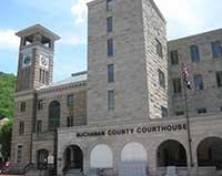
Buchanan County, VA Courthouse
The Buchanan County Courthouse is located in Grundy, Virginia.
The Clerk's Office DOES NOT DO RESEARCH . Most staff will assist people in finding the materials, but it is up to the individual to do the research.
The Buchanan County record dates below are from the earliest date to present time. They may include records of land, estates, taxes, vital records, divorces, naturalizations, voter registration, military discharges and court records.
County court records were destroyed by fire in 1885; records created after that date suffered extreme damage in a flood in 1977. A few re-recorded deeds exist.
- Buchanan County Clerk of Circuit Court has Marriage Records from 1885, Land Records from 1885, Court Records from 1885 and Probate Records from 1880.
- Buchanan County Treasurer
- Buchanan County Health Department
- County and City Research in Virginia Guides and Indexes
Buchanan County, Virginia Census Records
- Learn More: State of Virginia Census Records
- U.S. Federal Population Schedules: 1860, 1870, 1880 (free index), 1890 (fragmented), 1900, 1910, 1920, 1930, 1940
- U.S. Federal Census Slave Schedules: 1860
- U.S. Federal Census Mortality Schedules: 1860, 1870 and 1880
- Selected U.S. Federal Census Agriculture Schedules: 1860, 1870 and 1880
- Selected U.S. Federal Census Industry Schedules: 1860, 1870 and 1880
- Union Veterans Schedules: 1890
Buchanan County, Virginia Vital Records
- Learn More: State of Virginia Vital Records
- Birth & Death Records: from January 1853 to December 1896 and since June 14, 1912 to present. The Virginia Archives has copies of surviving birth and death records for the period 1853 to 1896
- Marriage Records: from January 1853 to present. The Virginia Archives has copies of marriage records prior to 1936.
- Divorce Records: from January 1918 to present.
- Locations: Virginia Office of Vital Statistics, Virginia State Archives
- Vital Records Online: USAVital or Social Security Death Index
- Vital Records by Mail: Birth Certificate, Marriage Certificate, Divorce Certificate, Death Certificate Applications.
- In Person: 2001 Maywill Street, Richmond, Virginia 23230

Buchanan County, Virginia Resources
- State of Virginia Archives and Societies
- RAOGK Volunteers for Virginia
- Buchanan County Public Library
- Buchanan Co Historical Society
- Buchanan County, Virginia Message Boards
- Buchanan County, Virginia Genealogy Forum
- Buchanan County microfilmed holdings at The Library of Virginia
- Virginia Heritage - Guides to manuscript and Archival Collections in Buchanan Co. Virginia
Buchanan County, Virginia External Links
- Virginia Historical Newspapers - Newspapers.com
- Historical Newspapers from Virginia (1784 - 1922 )
- Buchanan County, Virginia Books - Amazon
- Using County and City Court Records in the Archives at the Library of Virginia
- Virginia County Records, Volume , VI, VII , IX, X The records in these series were compiled as part of a series known as the Virginia County Records . The volume includes wills, land grants, and marriage bonds as well as other miscellaneous information on early Virginia settlers.
- Buchanan Co., Virginia - FindaGrave
- History of the Buchanan County Courthouse
- Buchanan County, Virginia Links - Cyndi's List
- Buchanan Co. VAGenweb
- Buchanan County, Virginia Ancestry Database Collections
- Virginia Revolutionary War Units
- Buchanan County, Virginia Military Records