King William County, Virginia Records
King William County, Virginia (Map It) was created in September 12, 1701 from King and Queen County . King William county was named for William III of England.
King William County is bordered by Caroline County (northwest), King and Queen County (northeast), New Kent County (south), Hanover County (southwest).
King William County Cities and Towns include West Point and King William.
MapGeeks.org has is a collection of old Virginia maps.
King William County, Virginia Courthouse Records
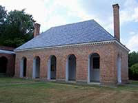
KingWilliam County, VA Courthouse
The King William County Courthouse is located in King William, Virginia. The King William County courthouse, erected early in the second quarter of the 18th century, is one of the older courthouses still in use in the United States. This T-shaped building was constructed of brick laid in Flemish bond, with an arcade imitating the first capital in Williamsburg. One of the best preserved of Virginia's colonial courthouse buildings, it features fine Georgian brickwork. About 1840 the courthouse was enlarged with a unique stile and a brick wall was erected to enclose the court green. Its rural historic setting is a rare survival.
The Clerk's Office DOES NOT DO RESEARCH . Most staff will assist people in finding the materials, but it is up to the individual to do the research.
The King William County record dates below are from the earliest date to present time. They may include records of land, estates, taxes, vital records, divorces, naturalizations, voter registration, military discharges and court records.
All county court records prior to 1885 (except for seventeen will books) were destroyed in a fire in that year.
- King William County Clerk of Circuit Court has Marriage Records from 1786, Land Records from 1701, Court Records from 1701 and Probate Records from 1701.
- King William County (VA) Treasurer
- King William County Commissioner of the Revenue
- King William County Health Department
- County and City Research in Virginia Guides and Indexes
King William County, Virginia Census Records
- Learn More: State of Virginia Census Records
- U.S. Federal Population Schedules: 1790 (destroyed), 1800 (destroyed), 1810, 1820, 1830, 1840, 1850, 1860, 1870, 1880 (free index), 1890 (fragmented), 1900, 1910, 1920, 1930, 1940
- U.S. Census Reconstructed Records: 1660-1820
- State Population Schedules: Virginia Heads of families 1790: records of the state enumerations, 1782 to 1785
- U.S. Federal Census Slave Schedules: 1850 and 1860
- U.S. Federal Census Mortality Schedules: 1850, 1860, 1870 and 1880
- Selected U.S. Federal Census Agriculture Schedules: 1850, 1860, 1870 and 1880
- Selected U.S. Federal Census Industry Schedules: 1850, 1860, 1870 and 1880
- Union Veterans Schedules: 1890
King William County, Virginia Vital Records
- Learn More: State of Virginia Vital Records
- Birth & Death Records: from January 1853 to December 1896 and since June 14, 1912 to present. The Virginia Archives has copies of surviving birth and death records for the period 1853 to 1896
- Marriage Records: from January 1853 to present. The Virginia Archives has copies of marriage records prior to 1936.
- Divorce Records: from January 1918 to present.
- Locations: Virginia Office of Vital Statistics, Virginia State Archives
- Vital Records Online: USAVital or Social Security Death Index
- Vital Records by Mail: Birth Certificate, Marriage Certificate, Divorce Certificate, Death Certificate Applications.
- In Person: 2001 Maywill Street, Richmond, Virginia 23230

King William County, Virginia Resources
- State of Virginia Archives and Societies
- RAOGK Volunteers for Virginia
- King William Historical Society
- King William County, Virginia Message Boards
- King William County, Virginia Genealogy Forum
- King William County microfilmed holdings at The Library of Virginia
- Virginia Heritage - Guides to manuscript and Archival Collections in King William Co. Virginia
King William County, Virginia External Links
- Virginia Historical Newspapers - Newspapers.com
- Historical Newspapers from Virginia (1784 - 1922 )
- King William County, Virginia Books - Amazon
- Using County and City Court Records in the Archives at the Library of Virginia
- Virginia County Records, Volume , VI, VII , IX, X The records in these series were compiled as part of a series known as the Virginia County Records . The volume includes wills, land grants, and marriage bonds as well as other miscellaneous information on early Virginia settlers.
- King William Co., Virginia - FindaGrave
- Important Date in the County's Establishment
- Old King William homes and families : an account of some of the old homesteads and families of King William County, Virginia
- King William County, Virginia Links - Cyndi's List
- King William Co. VAGenweb
- King William County, Virginia Ancestry Database Collections
- Virginia Revolutionary War Units
- King William County, Virginia Military Records